|
The Ozark Highlands
The primary Ozark mountain range in Missouri are found in the southeast of the state and are known as the Saint Francois Mountains, of which Taum Sauk is the highest point of both the Saint Francois mountains and of the state of Missouri. Other areas of the Ozark Highlands in Missouri include the Osage-Glasconade Hills, Salem plateau, Springfield plateau, and the River Hills ecoregions.
In the State of Arkansas, the entire northern section of the state have large areas that are included in the Ozark Highlands which include the Springfield Plateau, Salem Plateau and River Hills ecoregions.
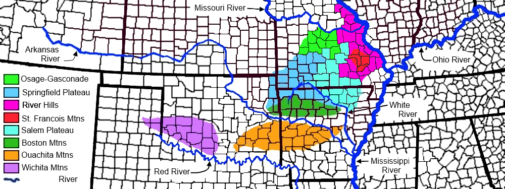
Osage-Gasconade Hills
Due to the large area, over 5000 square mile covered by the Osage river and Gasconade river hills, I have set this river hills as their unique ecoregion. This ecoregion can be found by clicking on the above up arrow to go back to the Galley Index Page, Missouri section.
Meramec River Hills
The region covers 1,776 square miles (4,600 km2) within Missouri along the Meramec River, of which river and streams all drain northeast first, through the Eastern Ozark Border area before arriving to the Mississippi river. This river route is very close to the Missouri river. This sub region is located just northwest of the St Francois mountains.
The Meramec River Hills ecoregion is deeply dissected, with steep-sided hills and ridges covered in chert. The hills here tend to be more rugged than in the Osage-Gasconade Hills ecoregion to the northwest.
Land use is mainly timber and recreation, with some pasture land for grazing, and barite and iron mining in the southeast closer to the alluvial plains.
The natural vegetation in this region is shortleaf pine-oak forest and woodland, with a greater oak concentration than found in forests of the Current River Hills which is to the southwest on the opposite side of the St Francois mountians.
Current River Hills
The region covers 3,114 square miles (8,070 km2) within Missouri along the Current river and all the river and streams drain southeast into the Mississippi river. This subregion is located directly southwest of the St Francois mountains upland a distance from the alluvial plains.
Much of the physical geography of the Current River Hills ecoregion is like that of the Meramec River Hills to the north. However, the Current river area has many endemic species not found in other Ozark regions.
The stream valleys contain, caves, losing streams and numerous, large, high-quality springs and is said to have better water quality than elsewhere in Missouri. A losing streams is one where the stream water generally goes underground.
Too, the natural vegetation here has higher pine concentration than in regions to the north and west. The region underwent intensive timber cutting in the early decades of the twentieth century, and now sustains major recreational activities.
Eastern Ozark Border
The ecoregion covers 1,835 square miles (4,750 km2) within Missouri and this ecoregion is a transitional area between the interior ecoregions of the Ozark Highlands and the Interior River Valleys and Hills ecoregion to the east. It lies east of the St Francois mountains as well as both the Meremec River Hills and the Black River Hills.
This area typically has moderately dissected hills and sheer bluffs. The land having rocky and thin soil on steep slopes but has areas of clay pan or loess similar to the Black Rivers Hills border with the plains on the southwest side. However, compared with plateau areas, the loess mantle in this region tends to be deeper and more expansive on the uplands.
The natural vegetation is a mix of oak forest, savanna, glades, and prairies. Land cover is variable with forests, woodlands, and cleared areas in cropland and pasture. This ecoregion has more cropland agriculture than other adjoining Ozark regions.
Black River Hills Border
The ecoregion covers 1,076 square miles (2,790 km2) within Missouri and is located southeast of the St Francois mountains between the mountains and the alluvial plains. This area like the Eastern Ozark Border is a transitional region that has moderately dissected hills with broad flat stream divides.
The natural vegetation is a mix between Ozark species on uplands areas and that of the Mississippi Alluvial Plain species in river bottoms. Land cover is predominantly forest and woodland with a scattering of pasture land and cropland in the cleared valley bottoms.
Soils are thin and rocky on steeper slopes, with claypan and loess in more level areas. More soils are derived from sandstone and loess, in contrast to interior Ozark Highlands regions which have soils mainly derived from dolomite.
This region has the highest precipitation in the Ozark Highlands with about 45 inches annually.
|