The Wayƒarers Journal ©

The Journal

The Wayƒarers

The Selƒ

The Journey

The Burden

The Mountain

   The Ancients
   The Earth

     Geochronology
     Continents

       Africa
       Antarctica
       Asia
       Europe
       North America

         Geographical
         Geological

           Arches
           Blue Holes
           Canyons
           Caves
           Craters
           Deserts
           Forests
           Hot Springs
           Mountains
           Parks
           Rock Spires
           Viewpoints
           Volcanoes
           Waterways

             Lakes
             Rivers
             Seas
             Springs
             Waterfalls
             Wetlands
             Water Divides

       Oceania
       South America

     Oceans

   The Life
   The Modern Man
   The Nonpareils
   The Steps
   The Way

The Appendix

The Wayƒarer
The Mountain
Go to bottom of this page
THE EARTH′S RIVERS AND RIVERWAYS
The Salmon River

The River of No Return Go Down go back
The Salmon River is entirely within the state of Idaho in North America. Originating high in the Sawtooth Mountains near Norton Peak in Lemhi county, it then flows north to Salmon, Idaho and then west to its confluence with the Snake River in the Hells Canyon national recreational area at a location just west of White Bird, Idaho in Nez Pierce county.
History:
Discovered in 1805 by Lewis and Clark, and explored with great difficulty by fur trappers and prospectors, the Salmon river drains a vast area of rugged mountains and deep canyons. This river did not allow passage by boats up the main canyon until 1950 and because of this had been called the River of No Return. There are still large areas of untamed wilderness in these mountains surrounding the Salmon river and some of it′s tributaries.

Salmon River Information
Confluence with Primary: 45.856389, -116.793611, Elevation 920 feet
Source: 43.796667, -114.776667, Elevation 9160 feet
Total Length: 425 miles (684 km)
Geographical Region Rocky Mountains of Idaho
Ecoregion Middle Rockies
Major Tributaries:
Tributaries Right:
East Fork Salmon River, Pahsimeroi River, Lemhi River,
North Fork Salmon River
Tributaries Left:
Yankee Fork, Panther Creek, Middle Fork Salmon River,
South Fork Salmon River, Little Salmon River

The Upper Salmon River Go Down Go Up
Friday, 13 August 2019, Forth of July Creek, ID.
(Day 325 TG) 43°F. 6:30 am, sunny, clear
Overnighting in a national forest
It is colder this morning than it has been for quite a few days and methinks that I have found a place where I might spend my summer hiatus. I was told that during the days, it does however, rise into the nineties during August but that it most every night still cools down to fifty degrees or lower. This morning I arise, dress, start the jammer to warm up the inside and soon after begin drive south on SH 75 continuing upstream along the Salmon river.
After a short drive, I come to a lodge and cafe and stop to buy coffee but have to wait almost an hour before it opens. I talk to a couple of hunters and find out that the highway continues to follow the Salmon river, now, no more that a creek and narrow enough to jump across. They also tell me that there is a hg-mart and w-mart in Ketchem, and that less than fifty miles.
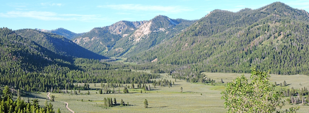
With coffee in my cup, I continue south upriver crossing the Salmon a couple more times before beginning my climb up to Galena Pass. On the way up, I stop at an overlook of the Salmon river valley and the valley up into the headwaters in the Sawtooth mountains.
The Salmon River
Source of the Salmon
(m2wa-riv-salmon.20190712.0822) The Salmon River Headwaters
Further up the mountain, I arrived at another overlook and could see clearly the river valley below me as well as the Sawtooth mountains in the backdrop. The source of the Salmon is about ten miles southwest into the distant mountain at the where the river rises at over 9200 feet on the north side of Norton Peak
The Salmon River
Source of the Salmon
(m2wa-riv-salmon.20190712.0825) The Salmon River Valley
At this road crossing, the Salmon has become no more than the size of most creeks, about six feet across and less than one foot deep.
The Salmon River
About Six feet Wide
(m2wa-riv-salmon.20190712.0807) The Salmon River, looking upriver to source
The Salmon River
About Six feet Wide
(m2wa-riv-salmon.20190712.0806) The Salmon River, creek size
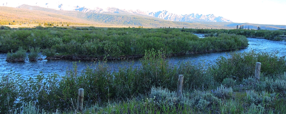
Earlier this morning, I broke camp crossed the Salmon River and began traveling upstream again and in a shot time, the river begins to reduced in width rapidly.
The Salmon River
Source of the Salmon
(m2wa-riv-salmon.20190712.0652) Moving again upriver along the Salmon
The Salmon River
Source of the Salmon
(m2wa-riv-salmon.20190712.0633) Camp in the national forest on the Salmon

The Salmon River below the Yankee Fork Go Down Go Up

The Salmon River below the East Fork of Salmon Go Down Go Up

The Salmon River below the Little Salmon River Go Down Go Up
Driving down the Little Salmon, I arrive in Riggins, Idaho where the Little Salmon flows into the Salmon river, after which the Salmon flows roughly eighty-five miles downriver before it′s confluence with Snake river. Stopping in Riggins city park and raft take out location. I take photos of the Salmon river as it now turns due north after the confluence with the Little Salmon.
The Salmon River below
the Little Salmon River
(m2wa-riv-salmon-bls.20190713.1127) Salmon River at Riggins city park overlook upstream
The Salmon River below
the Little Salmon River
(m2wa-riv-salmon-bls.20190713.1126) Salmon River at Riggins city park overlook downstream
The Salmon River below
the Little Salmon River
(m2wa-riv-salmon-bls.20190713.1130) Salmon River below the Little Salmon driving south on US 95
The Salmon River below
the Little Salmon River
(m2wa-riv-salmon-bls.20190713.1131) Salmon River below the Little Salmon driving south on US 95
The Salmon River below
the Little Salmon River
(m2wa-riv-salmon-bls.20190713.1134) Arch Bridge over Salmon River
The Salmon River below
the Little Salmon River
(m2wa-riv-salmon-bls.20190713.1143) Rock Face cut by the Salmon River
The Salmon River below
the Little Salmon River
(m2wa-riv-salmon-bls.20190713.1146) Arch-Truss Bridge combo over Salmon River
The Salmon River below
the Little Salmon River
(m2wa-riv-salmon-bls.20190713.1148) Scenic turns on US 95 along Salmon River
Salmon River Canyon
Fifteen million years ago, the river crossed the great Miocene lava flows above here and began carving this deep canyon. Later, the surface of the earth here gradually rose and as it did, the river cut down through older rock below the lava flows. The Salmon river here is only eight miles from the confluence with the Snake and Hells Canyon, the deepest of them all.
The Salmon River below
the Little Salmon River
(m2wa-riv-salmon-bls.20190713.1200) Salmon River enters Salmon River Canyon
The Salmon River below
the Little Salmon River
(m2wa-riv-salmon-bls.20190713.1206) Salmon River enters Salmon River Canyon
The Salmon River below
the Little Salmon River
(m2wa-riv-salmon-bls.20190713.1211) Salmon continues toward the Snake
The Salmon River below
the Little Salmon River
(m2wa-riv-salmon-bls.20190713.1213) Salmon continues toward the Snake
Shortly after this point, US 95 veers slightly east of the river to the climb up the White Bird grade to the Camas Prairie high above the river valley, while the Salmon river enters a desert wilderness and makes a sweeping arch to the west and then turns southward towards it′s confluence with the Snake River at the Idaho-Oregon Border just twelve miles south of Washington State.
The Salmon River below
the Little Salmon River
(m2wa-riv-salmon-bls.20190713.1242) Climbing up onto the Camas Prairie
Leaving the Salmon for Now
My journey now takes me away from the Salmon River for now as I climb up onto the Camas Prairie and head northward through vast fields of barley, canola, wheat, and other grains all at varying stages of growth, as I continue always in search for that ever so elusive perfect temperature where I may overnight.

To go back to River Index, click on down arrow. Go Back Go to previous section
on this page

Thank you for visiting The Wayƒarers Journal.

See Ya above the Treeline!

This Page Last Updated: 30 April 2026


To continue to the next Episode Level page, Click here go to top
 
The Wayƒarers Journal © ::: Come Join the Journey ™
by Thom Buras
Come Join the Journey ™