|
The Natchez Trace Trail: Mississippi
Natchez Trace Trail Description:
The Natchez Trace Trail is a National Scenic Trail (NST), designated in 1983, which trail is currently a fragmentary footpath of a total of just over 60 miles and generally follows the 444-mile
Natchez Trace Parkway (NTP). The NTP connects Natchez, Mississippi to Nashville, Tennessee along a roadpath that traverses the states of Alabama, Mississippi, and Tennessee.
The Natchez Trace Trail is not a long, continuous footpath, as is the case with other national scenic trails (such as the Appalachian Trail, Pacific Crest Trail, Continental Divide Trail and others); rather, it has only a limited number of trail segments which are sporadically found along the route of the Natchez Trace Parkway.
The current total combined distance of this footpath, which has been developed for both hiking and horseback riding is about 62 miles (less than 100 km) of trail. To walk any more than these designated 62 miles of footpaths would amount to a very long road walk along the side of the Natchez Trace Parkway without very many locations where there is a place to set up a campsite.
Truth be told, some have endeavored to walk more than the current sixty-two miles of footpath, and to do so, must needs follow along the shoulder of the Natchez Trace Parkway, as well as along both county and state roads. The Footpath Journey was originally intended to be longer and follow most of the Natchez Trace Parkway, but only a small portion of the national scenic trail was ever built. This is primarily due to the fact unlike many other trails that rely heavily on volunteers for trail construction and maintenance, the Natchez Trace NST is managed and maintained entirely by the National Park Service (NPS), which after asking a Park Ranger, discovered that the NPS organization has absolutely no plans to ever extend the footpath portion of the National Scenic Trail.
The Natchez Trace Parkway and the Natchez Trace National Scenic Trail both commemorate the original path that had been used for countless centuries on which walked many indigenous people, as well as early European explorers and settlers, Kaintuck boatmen, post riders, Meriwether Lewis, military troops and likely others.
National Scenic Trail Description:
The National Parkway is measured with numbered mileposts which numbering begins at the southern terminus near Natchez, Mississippi and marked as Milepost 0 (zero). The northern terminus is near Nashville, Tennessee and is marked as Milepost 444. The National Scenic Trail uses these numbered milepost to designate both the location and access to the trail heads.
The current status of the national scenic trail is that there are only five sections of somewhat short length, which all five are only accessed from the Natchez Trace Parkway. These five segments are listed below using the the National Parkway mileposts in the order of of the northernmost segment at the top and proceeding southward.
Natchez Trace Trail Information:
Trail Type:
National Scenic Trail
Trail Management:
National Parks Service
Trail Total Length:
62 miles, 99.8 km
Trail Segment Lengths:
Tennessee Segment Five, 20 miles
Highland Rim Trail, Milepost 407.9 to 427.4
Footpath and equestrian only, no bicycles. No Camping in this section.
Mississippi Segment Four. 6 miles
Blackland Praire Trail, Milepost 260 to 266
Footpath and equestrian only, no bicycles.
Mississippi Segment Three, 25 miles
Yockanookany Trail, Milepost 107.9 to 130
Footpath and some equestian. No camping in this section.
Mississippi Segment Two, 6 miles
Rocky Springs Trail, Milepost 52.4 to 59
Footpath and some equestrian. No camping in this section.
Mississippi Segment One, 3 miles
Potkopinu Trail, Milepost 17 to 20
Footpath only. No camping in this section.
Trail Use:
hiking, some equestrian
Trail Waymark:
White blazes
alternately, the trail is marked with brown and white signs
Trail Elevation:
Highest Elevation on Trail:
1043 feet,
Lowest Elevation on Trail:
101 feet,
Geographical Information:
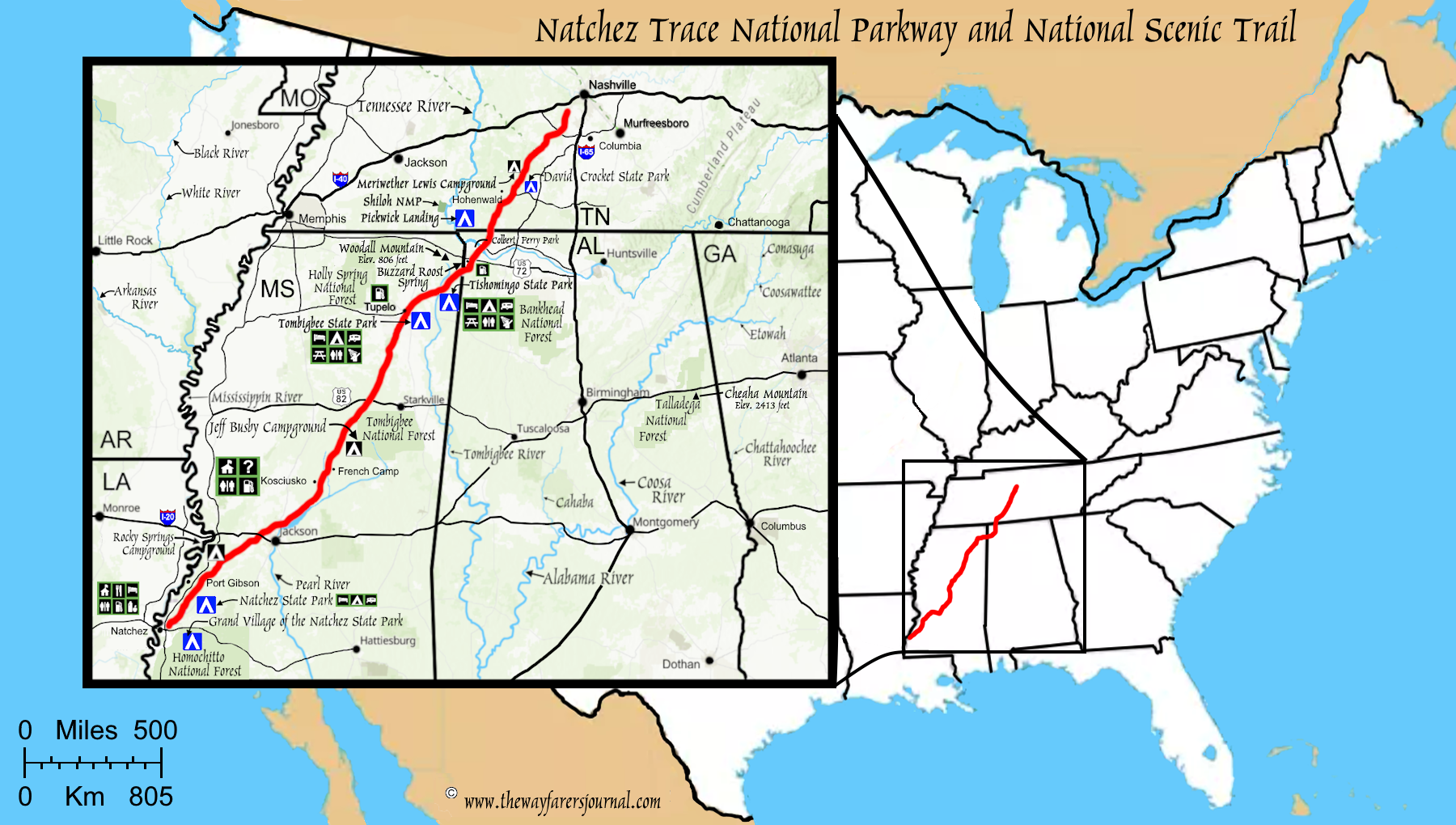
(m0-maps-natchez-map) Natchez Trace Trail Map
The old Natchez Trace traveled through the lands of the Chickasaw, Choctaw, Natchez and other indigenous people, all of which are part of the
Muskoge nation of native Americans.
Rocky Springs, Milepost 54, (RV, tent, bicycle)
Kosciusko, Milepost 160 (bicycle-only)
Jeff Busby, Milepost 193.1, (RV, tent, bicycle)
Witch Dance, Milepost 234 (bicycle-only)
Natchez Trace Parkway Visitor Center, Milepost 266 (bicycle-only)
Colbert Ferry, Milepost 327 (bicycle-only)
Meriwether Lewis, Milepost 385.9, (RV, tent, bicycle)
Tennessee Highway 50, Milepost 408, (bicycle-only)
Each Parkway campground provides tent sites, picnic tables, and fire grates throughout the year. Water is available throughout the year inside Parkway restrooms. There are no showers or electricity at any of the campgrounds.
There is no dispersed camping allowed.
|