|
The Pacific Northwest Trail
The Pacific Northwest Trail (PNT) is a 1,200-mile (1,900 kilometer) National Scenic Trail (NST) in the United States that traverses the northernmost reaches of the states of Montana, Idaho, and Washington, extending from the Continental Divide in Glacier National Park, in the state of Montana, to the Pacific Ocean on the Olympic Peninsula at Cape Alva in state of Washington. Along the route, this footpath traverses 3 national parks (NP), 7 national forests (NF), 6 wilderness areas (WA) and 2 other national scenic trails. It is said that the PNT travels against the grain of many of the mountain ranges it traverses, including: Continental Divide, Whitefish Divide, Purcells, Selkirks, Kettles, Cascades, and Olympics.
This trail is known for being rugged, wild, and physically demanding; it offers a unique Crown-to-Coast adventure, passing through diverse and bountiful earthscapes such as: historic towns, sagebrush parkland, national parks, alpine meadows, old growth forests, high mountain ranges and rugged beaches, all of which contain a diversified number of wildlife species.
Too, this trail serves as a connector-trail for two other National Scenic Trails, at their northern terminuses and for those who might desire to walk the two trails contiguously: the Continental Divide NST and the Pacific Crest NST.
The Founding of the PNT
The originator of the concept of a connector trail from the Continental Divide to the Pacific Ocean was a long-time backpacker named Ron Strickland in the early 1970s, who became instrumental in its route formations and in 1977, the founding of the Pacific Northwest Trail Association (PNTA), which association of volunteers worked tirelessly to develop, preserve and protect the newly forming trail corridor.
Ron Stickland is quoted in saying: "The Pacific Northwest Trail starts like a drop of rain on the flanks of the Continental Divide and winds its way west, like a river that flows to the Pacific Ocean."
In 1977, the first five successful thru-hikes of the Pacific Northwest Trail were completed. In 1984, the first full length guide book was published and in 2009, the Pacific Northwest Trail became designated by Congress as a National Scenic Trail.
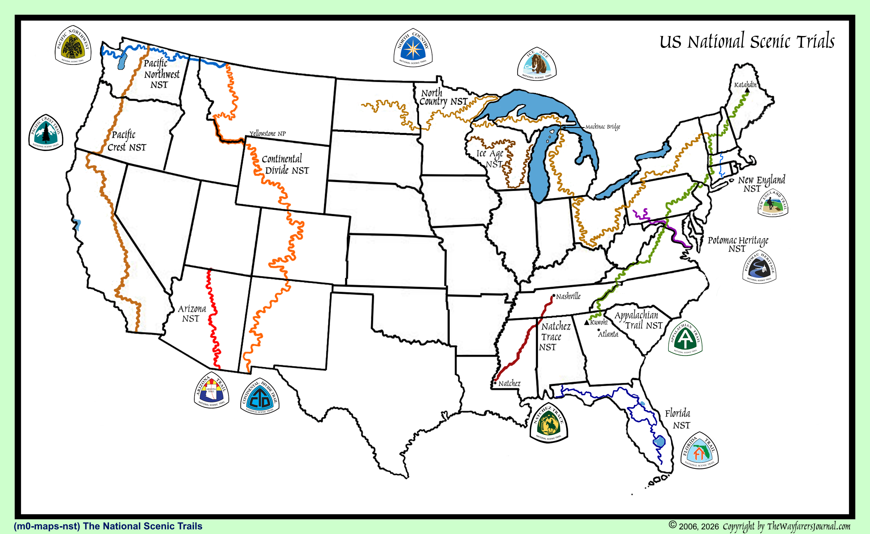
(m0-maps-nst-map) National Scenic Trails Map
Footpath Route Description:
At the eastern terminus at Chief Mountain Customs on the United States–Canada border in northwest Montana, the Pacific Northwest Trail traverses the high mountains and valleys of Glacier National Park, where it shares mileage with the Continental Divide Trail. Then it enters Flathead National Forest, travels across the Flathead River into Polebridge, Montana, up the Whitefish Divide, into Kootenai National Forest, and through the Ten Lakes Wilderness Study Area on its way to the Idaho state line.
In Idaho Panhandle National Forest, the PNT crosses the Moyie River Valley, winds its way through the forest lands, dikes, and farmlands of the Kootenai River Valley, up Parker Ridge to the Selkirk Crest, then down Lions Head and over Lookout Mountain to Upper Priest Lake. From there, the trail climbs toward the Washington state line. Next, the trail wends along the Kettle Crest, through Okanogan-Wenatchee National Forest and into the range lands and orchards of the Okanogan River Valley. From the city of Oroville, Washington, the PNT follows the Similkameen River to Palmer Lake, where the trail travels through Loomis State Forest, and then begins its ascent into the Pasayten Wilderness, where the PNT shares tread with the Pacific Crest Trail.
Along the dikes and through the farmlands of Skagit County, the trail traverses Fidalgo Island, crosses the bridge at Deception Pass State Park and continues across Whidbey Island to the Washington State Ferry Terminal in Coupeville, Washington. After a thirty-minute ferry ride, the trail picks up in the seaside community of Port Townsend, Washington and the confluence of three trails: the Larry Scott Trail, the Olympic Discovery Trail, and the Pacific Northwest Trail. The trails circumnavigate the northeastern tip of the Olympic Peninsula and Discovery Bay before going their separate directions, with the PNT turning southwest through Olympic National Forest, Buckhorn Wilderness and into Olympic National Park.
As the trail leaves the park and travels along the Bogachiel River it finds its way through the northern end of the Hoh Rain Forest to the Pacific Ocean at the mouth of the Hoh River. There, the trail turns north and wends along the wilderness coast where it enters the Quileute Indian Reservation near the town of La Push, then continues north to its western terminus at Cape Alava.
Footpath Information:
Footpath Administrator:
United States Forest Service (USFS)
Footpath Type:
National Scenic Trail
Year NST Status Established:
2009
Footpath Trail Maintenance:
Pacific Northwest Trail Association
Year Footpath Established:
1977 - First Thru-hikes Completed
Footpath Elevations:
Highest Elevation:
7569 feet
Cathedral Pass, Washington
Lowest Elevation:
0 feet
Pacific Ocean at Cape Alva
Footpath Length:
Total Length::
(2026)
1226 miles, 1973 kilometers
Length in Montana
~ 260 miles
Length in Idaho:
~ 180 miles
Length in Washington:
~ 760 miles
Footpath Parks:
Parks in Montana:
Continental Divide NST, Glacier NP, Kootenai NF
Parks in Idaho:
Selkirk Mountains, Priest Lake
Parks in Washington:
Pasayten Wilderness, North Cascades NP, Pacific Crest NST, Puget Sound Ferry, Olympic NP
Footpath Use:
Foot travel, and in some areas: bicycles and equestrian travel
Footpath Waymark:
Sporadicly with Yellow Thunderbird Trail Marker Plaque, but largely unmarked

(m6fo-wa-pnt-thunderbird) The Thunderbird Trail Marker Plaque on the PNT in Washington
Footpath Terminus Points:
Location:
Glacier National Park, Montana
Continental Divide Trail
Coordinates:
49.000000, -120.800000
Elevation:
feet
Western Terminus:
Western
Location:
Pacific Coast of Washington
Cape Alava
Coordinates:
48.166667, -124.733333
Elevation:
feet
Footpath Animal Habitat:
Mammals:
Habitat is provided for bighorn sheep, deer, gray wolf, moose, mountain goats, mountain lions, and is home to the largest population of lynx in the Lower contiguous forty-eight.
Geographical Information:
Montana
The trail in Montana only crosses one Geographical Region (GR) and one Ecoregion Area (EA).
Geographical Region:
Rocky Mountains
Montana Geographic Features:
Sections of the trail in Montana feature soaring peaks, high passes, and glacial valleys.
Along the trail are off-the-grid communities and some six historic fire lookouts.
Idaho
The trail in Idaho also crosses the same GR and EA as did Montana.
Geographical Region:
Rocky Mountains
Idaho Geographic Features:
The trail in Idaho descends into and crosses the Kootenai Valley.
Then the trail climbs into the Selkirk Mountains and then into an area of the Pacific Northwest rain forest.
Washington
This state, with the longest amount of trail, the hiker crosses three separate GRs and five separate EAs.
First, the Rocky Mountains GR and Northern Rockies EA.
Next, the Basing and Range GR and the Columbia Plateau EA.
Finally, the Pacific Coastal GR and three of its EA.
Geographical Region:
Rocky Mountains
Washington Geographical Features:
Washington, the longest part of the PNT begins with crossing the Kettle River Range and the Okanogan Highlands, after which the rain forest climate evaporates into the more desert-like Columbia River area. After crossing the Columbia River at Northport, Washington, the PNT joins the Kettle Crest National Recreational Trail and continues westbound to Oroville, Washington.
Geographical Region:
Basin and Range
Washington Region Features:
From Oroville, the PNT climbs up into the USNF Pasayten Wilderness, a vast pristine area, much of which borders Canada to the north. Traveling westward, the hiker first ascending out of the Columbia Valley up onto the open plateau grassland of the Columbia Plateau. Then, the ascent continues towards the Mountains in the west, elevations continue to increase and the slope becomes alpine.
Geographical Region:
Pacific Coastal
Washington North Cascade Ranges Features:
Upon reaching the Pacific Crest Trail NST, the hiker then continues on the western side of the Cascade Mountains, the earthscape transitions to have abundant dramatic jagged crags, deep canyons, turbulent waterways tall peaks and ridges. This is where the Pasayetn Wilderness begins.
The Pasayten is the traditional hunting territory of the Nlaka′pamus indigenous people in nearby counties in Canada.
Next, the footpath route enters the Ross Lake National Recreation Area, travels south on the east side lake trail, over Ross Lake Dam and north along the west side lake trail, then the Beaver Creek trail, Little Beaver Creek Trail, during which the footpath route transitions into the North Cascades NP. Continuing west to Mount Baker ski area, the south from there along the South Fork Nooksack River,
Washington Salish Basin Features:
After descending from Mount Baker southward along the east bank of the South Fork Nooksack River, the footpath route follows the ridge above the rivers continuing into the Samish Basin ecoregion decreasing in elevation and dropping down towards Skagit Bay and North Puget Sound waterway, both of which must be crossed by bridge and/or ferry. Eventually, the route crosses the Deception Pass Bridge, traverses Deception Pass State Park, Fort Ebey State Park, Fort Casey State Park and arrives at the Keystone Ferry Lnading where the PNT route continues aboard the ferry to cross the Puget Sound to Port Townsend on the Olympic Penninsula.
Washington Coastal Ranges Features:
Arriving on the western ferry landing, the PNT route heads out to the southwest along the edgewater pathway known as the Larry Scott Trail, an arm of the Olympic Discovery Trail. The PNT then travels westward on the
the several trails that are found crossing the Olympic National Park (ONP) to the western end of that national park, then leaves the ONP along the north shore of the Bogachiel River to where the river arrives at US 101 south of Forks, Washington. From this road intersection, the PNT turns south through a regions of mostly state forest, traversing the area on forest roads and/or forest trails. Upon arriving at the Hoh River, the PNT trail turns west and follow the Hoh River to the Washington coast. Upon arriving at the coast, the PNT enters a section of the Olympic National Park which narrow strip of land about seventy miles along the coast but only a few miles wide. One on the coast, the PNT then turns north to follow this narrow coastal part of the national park, beginning just north of the Hoh Indian Reservation, continuing north to the Quileute Reservation. Then the PNT departs the coast briefly inland, moving east on SH 110 in order to cross the Sol Duc river and its tributary, the Bogachiel River, after which the PNT returns to is northbound trek along the Olympic National Park coastal section from La Push all the way to Cape Alava just before arriving at the Ozzette Reservation.
|